
Copenhagen Metro map
All four lines and every one of the 44 stations on one map — view it here or download the PDF for your phone.
Checked: september 2026
Download the Copenhagen Metro map as a PDF
The PDF is vector, so it stays sharp however far you zoom, and it opens with no signal — worth saving before you land. Tap the map to open the full-size image, or use the download button underneath.
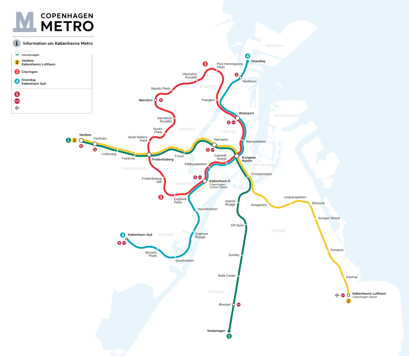
Network map by tomtom, CC BY-SA 4.0, via Wikimedia Commons — redrawn to the network as it runs today.
Reading the map: lines, colours and interchanges
The four lines
Interchanges. 14 stations are served by more than
one line: Christianshavn, Fasanvej, Flintholm, Forum, Frederiksberg, Gammel Strand, Kongens Nytorv, København H, Lindevang, Marmorkirken, Nørreport, Rådhuspladsen, Vanløse and Østerport. Every one of them is a single station — changing line means crossing a platform, not
leaving and re-entering.
M1 — Vanløse to Vestamager
M1
Vanløse ⇄ Vestamager
15 stations
M2 — Vanløse to Lufthavnen
M2
Vanløse ⇄ Lufthavnen
16 stations
M3 — the city circle
M3
Circle line — trains run both ways round
17 stations
↻and back round to København H — 21 minutes for the full circle
M4 — Orientkaj to København Syd
M4
Orientkaj ⇄ København Syd
13 stations
Which zone is each station in?
Which zone is my station in?
| Zone | Metro stations | Count |
|---|---|---|
| Zone 1 | Aksel Møllers Have, Amagerbro, Christianshavn, Enghave Brygge, Enghave Plads, Forum, Frederiksberg Allé, Gammel Strand, Havneholmen, Islands Brygge, Kongens Nytorv, København H, Lergravsparken, Marmorkirken, Nordhavn, Nuuks Plads, Nørrebros Runddel, Nørreport, Orientkaj, Poul Henningsens Plads, Rådhuspladsen, Skjolds Plads, Sluseholmen, Trianglen, Vibenshus Runddel, Østerport | 26 |
| Zone 2 | Fasanvej, Flintholm, København Syd, Lindevang, Mozarts Plads, Nørrebro, Vanløse | 7 |
| Zone 3 | Amager Strand, Bella Center, Femøren, Sundby, Vestamager, Ørestad, Øresund | 7 |
| Zone 4 | Kastrup, Lufthavnen | 2 |
| Zone 1/2 | Frederiksberg | 1 |
| Zone 1/3 | DR Byen | 1 |
A ticket is priced by how many zones your journey touches, with a minimum of two. Two stations that share a zone still need a two-zone ticket. Frederiksberg and DR Byen sit on a zone boundary and count as either of the two shown.
Map questions
Printed network maps are posted at every station, on every platform and inside every train, and the ticket machines show one too. The PDF on this page is the one to keep on your phone.
The map on this page is drawn to the real geography of the city, with the coastline and the harbour, so it doubles as a rough guide to where the districts are. The diagrams further down this page are schematic and show the running order of the stations.
Vanløse, Flintholm, Nørreport, København H, København Syd, Nørrebro, Østerport and Nordhavn. Nørreport, København H, Østerport and Ørestad also have regional and InterCity trains.
Look for the colour of your line first, then follow it — every line runs in a single colour end to end. Interchanges are drawn as a larger white circle. The station list on this page links to a page for every one of the 44 stations.